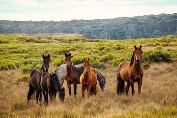
Fire data analysis released by the Invasive Species Council today shows the bushfires that raged across eastern Australia last summer likely had very little impact on the areas of Kosciuszko National Park where feral horses are known to gather in large numbers.
“We now know that while more than a third of Kosciuszko National Park burnt during last summer’s bushfires most of the areas favoured by horses escaped the fires,” Conservation Officer Candice Bartlett said today.
“Our analysis of the pattern, severity and extent of the bushfires that swept through Kosciuszko National Park clearly shows feral horse strongholds remained largely unburnt.
“This analysis refutes claims by horse advocates, including NSW deputy premier John Barilaro, that many horses died in the fires and that plans to reduce the number of horses in Kosciuszko National Park are no longer necessary.
“The 2020 summer bushfires were devastating to the native plants and animals of Kosciuszko National Park and recovery for the park and its wildlife will be slow and painful.
“The latest reliable population estimate of horse numbers in Kosciuszko National Parks suggests that in April and May last year there were about 20,000 horses, give or take a few thousand.
“This fire analysis backs up ground and aerial observations after the fires that large numbers of horses remain in Kosciuszko National Park and reinforces the need for post-bushfire recovery horse removal.
“Kosciuszko’s struggling wildlife should not have to compete for scarce food and shelter with the hard-hooves of feral horses.
“The NSW government restarted trapping efforts in June 2020 after a two-year hiatus, but has only targeted three areas, two of which were burnt severely – the Kiandra/Boggy plains and Nungar Plains – and the largely unburnt but sensitive Cooleman Plain.
“Given the damage to Kosciuszko National Park and its native wildlife and the recent years without removing any feral horses, there are now higher grazing levels of more feral horses on smaller productive areas.
“There is now an extremely compelling case for accelerated feral horse removal.”
About the analysis
The Invasive Species Council commissioned a GIS analyst to review the burnt areas of Kosciuszko and available horse presence data.
The analysis started with the area within Kosciuszko National Park which were surveyed in 2014 and 2019 for feral horses. This represents the most reliable information of areas of high horse concentration in the park. Horses in lower numbers are found in the national park outside this area.
The horse survey area was overlaid with mapping of fire severity and extent mapping prepared by the NSW Department of Planning, Industry and Environment. This is the most reliable data available that shows where the summer 2019-20 bushfires burnt and their severity. The maps are generated from satellite imagery and an automated process that seeks to determine the fire intensity based on the loss of vegetation and canopy condition. Data intensity is recorded in 10 metre pixels and fire extent is accurate to within 2km.


